- Hindi news
- National
- India Bangladesh Map Controversy; S jaishankar congress | Bihar Jharkhand Odisha
New Delhi2 minutes ago
- Copy link
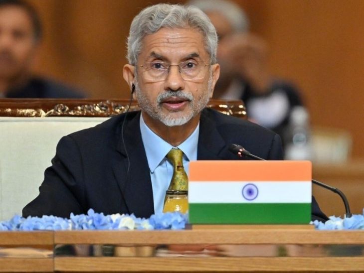
External Affairs Minister S Jaishankar has given a written reply in the Rajya Sabha on 31 August.
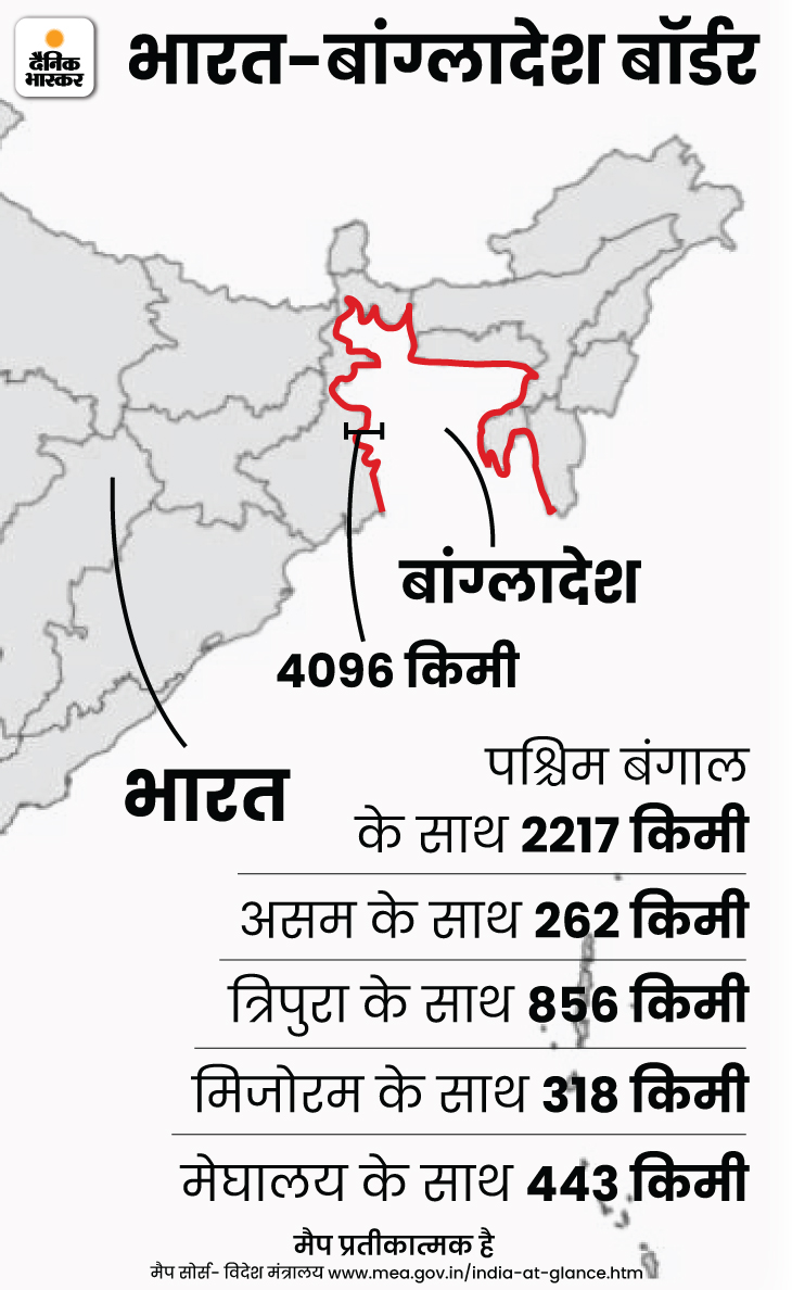
The issue of disputed map of Bangladesh also arose in Parliament. 7 states of India, West Bengal, Assam, Meghalaya, Tripura, Bihar, Jharkhand and parts of Odisha are shown in the map of Bangladesh. Congress leader Randeep Surjewala questioned this in the Rajya Sabha on Thursday.
Surjewala said- what is the government doing on this issue. External Affairs Minister S Jaishankar said in a written reply- We are keeping a close watch on this matter. The government is fully prepared to deal with such propaganda.
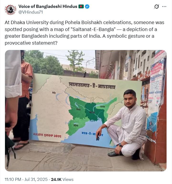
On 31 July, a Hindu organization in Bangladesh posted a picture of the disputed map and questioned the Bangladesh government.
Now know what is the whole matter According to the statement of the Ministry of External Affairs, the disputed map was organized in an exhibition held at Dhaka University on 14 April 2025. It is alleged that a map of Greater Bangladesh has been prepared by the Islamic group ‘Sultanate-e-Bangla’ in Dhaka.
‘Sultanate-e-Bangla’ is supported by a Turkish NGO named ‘Turkish Youth Federation’. Turkish-Bangladesh relations have strengthened after the arrival of Mohammad Yunus, Chief Advisor of the Interim Government of Bangladesh. The activities and military cooperation of Turkish NGOs have also increased.
Surjewala raised the issue in Rajya Sabha, 2 questions
- Surjewala had sought information from the government about a radical group -backed group in Bangladesh about the disputed map. Which is involved in promoting the ‘Greater Bangladesh’ map by incorporating parts of Indian territory.
- The Congress leader questioned whether the government has taken the issue diplomatically with the Bangladesh government and whether the government has assessed the security implications of the increasing participation of Turkey and Pakistan in Bangladesh.
Foreign Minister’s reply, in 4 points
- The government has taken cognizance of reports that have released a map of ‘Greater Bangladesh’ by an Islamic group called ‘Sultanate-e-Bangla’ in Dhaka which includes parts of India.
- The Bangladesh government’s fact checker platform ‘Banglafact’ has claimed that there is no evidence of the operation of ‘Sultanate-e-Bangla’ in Bangladesh.
- The statement further clarified that this ‘map’ was displayed in a historic exhibition in the context of the so -called old Bengal Sultanate.
- The Government of India is keeping a close watch on all developments that have an impact on India’s national security and keeps taking all necessary measures for its safety.
Last year too, such a disputed map was revealed
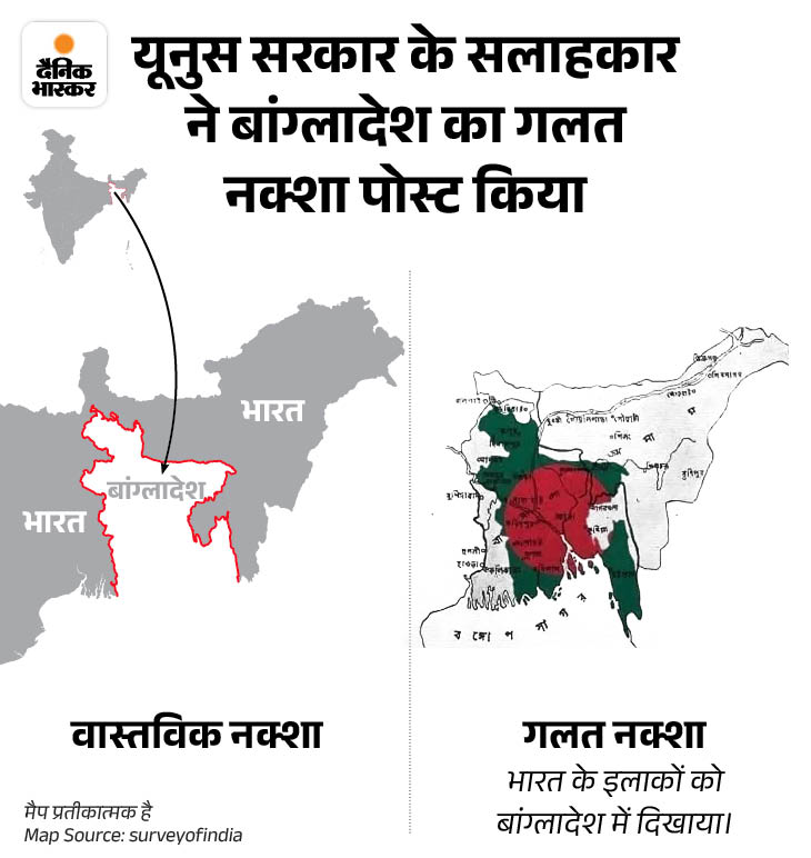
In December 20024, Mahfooz Alam, advisor to the interim government chief Mohammad Yunus, posted a wrong map of Bangladesh. In this map, Mahfooz Alam showed India’s Bengal, Tripura and some part of Assam in Bangladesh. However, this post was deleted as the dispute escalated.
Sheikh Hasina’s coup In 1947, East Pakistan separated from India and became a new country. In 1971, East Pakistan separated from West Pakistan and became Bangladesh. In 1975, the first President Sheikh Mujibur Rahman was killed by the Bangladeshi army. At the same time, Prime Minister Sheikh Hasina was coup on 5 August 2024.
,
Read this news too …
Government imposed new restrictions on Bangladeshi goods: India’s textile market benefits
India has imposed new sanctions on imports from Bangladesh. The move is likely to put further pressure on the weak economy of Bangladesh. It was announced on 17 May by the Directorate General of Foreign Trade (DGFT) under the Ministry of Commerce and Industry, Government of India. Read full news …